Towns and Wards
We have used Public Health England’s Local Health Tool to produce profiles for the major towns in Cambridgeshire, presenting the key health-related data available at small area level. We have also produced profiles for Peterborough’s urban and rural areas.
IMPORTANT NOTE RELATING TO THE DEVELOPMENT OF THE TOWN PROFILES 2019:
Town boundaries can be defined by grouping together one or more constituent geographical areas based on the underlying geography and where data are available.
Two such geographical areas are wards and MSOAs (Middle-Super output areas). MSOAs are a small area geography.
Wards and MSOAs sometimes have different footprints, and so it is important to know which geographical area is covered by them before you decide which one is the most appropriate to use for the town and data set you require.
It is also important to note that some datasets are only available by ward or by MSOA and very important to note that the town boundaries used here are not formally defined and are based on ‘best fit’ MSOA and/or ward geography and data availability.
An example:
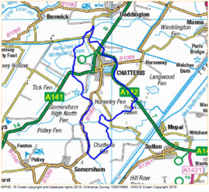
The blue line on the map below represents the boundary of the town of Chatteris as defined by four wards (Birch, Mills, Slade Lode and Wenneye).
The blue line on the map below represents the boundary of the town of Chatteris as defined by one MSOA (MSOA: Fenland 011).
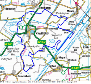
As the maps show, the ward and MSOA boundaries for Chatteris are different, and therefore the data for these areas may be different.
For some towns the alignment of the ward(s)/MSOA(s) is a better ‘fit’ than for others. It is important to consider that data can be potentially misrepresentative if too much of a rural area is included within part of an underlying geography that is, in part, an important area of the town.
In order to provide as much access to data as possible, we have produced town profiles by both ward and MSOA boundaries using Local Health data. It is important that both profiles are considered when using the datasets.
East Cambridgeshire
- Ely town profile – MSOA boundary
- Ely town profile – Ward boundary
- Littleport town profile – MSOA boundary
- Littleport town profile – Ward boundary
- Soham town profile – MSOA boundary
- Soham town profile – Ward boundary
Fenland
- Chatteris town profile – MSOA boundary
- Chatteris town profile – Ward boundary
- March town profile – MSOA boundary
- March town profile – Ward boundary
- Whittlesey town profile – MSOA boundary
- Whittlesey town profile – Ward boundary
- Wisbech town profile – MSOA boundary
- Wisbech town profile – Ward boundary
Profile of rural wards in Fenland District not included in the Town Profiles: Fenland rural – Ward boundary
Huntingdonshire
Huntingdon town profile by wards has not been included as the ward boundaries do not align well to the Huntingdon urban area.
- St Ives town profile – MSOA boundary
- St Ives town profile – Ward boundary
- St Neots town profile – MSOA boundary
- St Neots town profile – Ward boundary
South Cambridgeshire
Peterborough
Profile of urban wards/MSOAs covering the city of Peterborough:
Profile of rural wards/MSOAs in Peterborough Local Authority not included in the City Profile: