Cambridgeshire Road Traffic Collision Data
This page outlines how road traffic collision data can be obtained for Cambridgeshire:
-
-
- If you require collision data for Peterborough, please contact: Jenny.Wright@peterborough.gov.uk.
- If you require collision data for Cambridgeshire, please read the information below.
-
Page Contents:
Where does the data come from?
How up to date is the data?
Which dataset should I use to prepare a Transport Assessment/Statement or Road Safety Audit?
How can I download the basic data (free)?
How can I request data that includes collision descriptions and road safety factors (charges apply)?
How much are the charges for a bespoke collision data request?
Where does the data come from?
Road traffic collision records are provided to CCC by the police. The records are cleaned by CCC officers before being included in CCC’s road traffic collision database. The dataset only includes collisions that meet the Department for Transport (DfT) STATS19 definition of a road traffic collision:
“Involves personal injury occurring on the public highway (including footways) in which at least one road vehicle or a vehicle in collision with a pedestrian is involved and which becomes known to the police within 30 days of its occurrence. Damage-only accidents, with no human casualties or accidents on private roads or car parks are not included.”
For further information about collision reporting and data collection, please refer to the Department for Transport STATS 19 and STATS 20 guidance.
How up to date is the data?
The road traffic collision data is available in two versions:
-
-
- The local dataset (provisional) which is updated on a weekly basis. This dataset includes the most recent records and provides the latest picture which is subject to change. The local dataset is available to view using the CCC Road Safety Dashboard and can be downloaded here. For more detailed data, including collision descriptions and road safety factors, a bespoke request can be made. CCC officers can also view the data using the MapInfo Map Tree.
- The national dataset which is verified by DfT in summer/autumn each year for the previous calendar year. This dataset is more stable but doesn’t provide the latest picture due to being updated on an annual basis. DfT have currently verified data up to the end of 2024 and we expect the 2025 data to be verified in September 2026. The DfT-approved dataset is available to view on the DfT Road Safety Statistics webpage.
-
The key differences between the local and national datasets are summarised in our annual note:
Which dataset should I use to prepare a Transport Assessment, Transport Statement or Road Safety Audit?
Road safety professionals preparing Transport Assessments, Transport Statements and Road Safety Audits are advised to make a bespoke request for detailed collision data that includes collision descriptions and road safety factors.
Collision descriptions and road safety factors may not be shared publicly so these data fields are not included in the free collision data download so a bespoke request should be made following the collision data request instructions below (charges apply).
It is recommended that the local dataset is used for this purpose because the DfT’s national dataset does not cover the latest 9-20 months (depending on the time of year) whereas the local dataset is typically complete for all but the latest 2-3 months.
How can I access the local dataset?
If you require up to date collision data (i.e. the local dataset), there are different ways to access this data depending on your use case and the level of detail we are permitted to share:
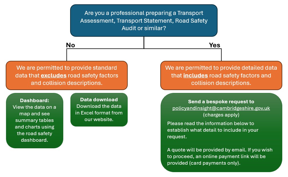
1. Collision data download (free)
The local road traffic collision dataset (Cambridgeshire only) is available for immediate, free-of-charge download in Excel format here: Cambridgeshire Road Traffic Collision Data. This data is also available to view in our Road Safety Dashboard, which includes a range of maps, tables and charts.
Please note, the data that is publicly available to download:
-
-
- is currently provisional for 2025 and is therefore subject to change.
- does not include collision descriptions or contributory factors / road safety factors – we are only permitted to share this information with parties engaged in accident investigation, accident remedial works and/or safety engineering.
-
We have produced a guide to help you extract the collision data for a specific area of interest (e.g. a certain town or road). It also covers how to extract the data if you have been provided with a shapefile of an area of interest. Please see the guide here: Guide to extracting collision data in your area of interest.
If you are unable to download the data, please make a request to the CCC Policy & Insight team following the steps below.
2. Bespoke request for collision data (charges apply)
If you are unable to download collision data using the process outlined above, you can make a request for data to the CCC Policy & Insight team by following the steps below. The provision of collision data is a chargeable service, unless you are working on behalf of GCP or CCC.
Step 1. Check the collision data map
Please use the map available on our Road Safety Dashboard to view your area of interest and confirm whether there are any collisions recorded. If there are no collisions on the map in your area of interest, we do not have a record of any personal injury collisions in this area since 2017.
Step 2. Request the data
Send a data request email to policyandinsight@cambridgeshire.gov.uk.
Please make sure your email outlines the following:
-
-
-
-
- the date range you require data for (e.g. July 2019 to June 2021)
- your area of interest – ideally defined by a polygon using a shapefile or DXF but an image or a detailed description is acceptable for smaller requests.
- the format you wish to receive your data in – note that our standard format is an Excel spreadsheet and an additional charge is payable for other formats.
- whether you require collision descriptions and contributory factors.
- the purpose of your request – this is to establish whether the nature of your work is considered to relate to accident investigation, accident remedial works and/or safety engineering. We are only permitted to provide collision descriptions and contributory factors to parties engaged with this nature of work.
- copy your project sponsor into the email if you are working on behalf of GCP or CCC.
-
-
-
If you are requesting data for the purpose of a Transport Assessment/Statement or Road Safety Audit, please make sure it’s clear that you require collision descriptions and contributory factors. This will help us to direct your request accordingly.
Step 3. Quote
The Policy & Insight team will respond to your request with a quote. If you would like to proceed with purchasing the data, please accept the quote by email and we will arrange for payment to be taken online by credit/debit card.
Charges:
The provision of bespoke collision data is a chargeable service, unless you are working on behalf of GCP or CCC.
From 1st April 2025, a £390+VAT standing charge will apply to all collision data requests that are fulfilled by the CCC Policy and Insight team on behalf of external parties. The standing charge covers the data query and the supply of the data in Excel and/or Shapefile format. The following extra fees will also apply where appropriate:
-
-
-
-
-
- Larger requests exceeding 1,000 collisions (£112+VAT per additional 500 collisions).
- Alternative data export formats (£450+VAT).
-
-
-
-
Please note, we are only permitted to share collision descriptions and contributory factors with parties engaged in accident investigation, accident remedial works and/or safety engineering.
Step 4. Data provision
Once payment has been taken, we will provide you with your collision data in the format requested within 15 working days unless specified otherwise.
Cluster site analysis
Collision cluster site analysis is undertaken by CCC on an annual basis to identify locations on the public highway where a higher number of injury collisions are occurring. CCC define a collision cluster site as follows:
-
-
- 6 or more injury collisions (any severity) within 100m or at a junction, in the most recent 3 calendar year period; or
- 3 or more higher severity injury collisions (fatal or serious injuries) within 100m or at a junction, in the most recent 3 calendar year period.
-
The latest identified cluster sites can be viewed on Maps Cambridgeshire by selecting the “Transport and Streets” drop-down and ticking on the “Accident Clusters” layer. We aim to update the cluster analysis in Autumn/Winter each year.